
Iceland’s Spectacular Southern Region – Detailed Guide for Your Next Trip!
This post may contain affiliate links. There is a chance that I might receive a commission for purchases made through these links at no cost to you, of course!
Iceland’s southern coast is filled with waterfalls, black sand beaches, glaciers, and geothermal activity! It’s the most accessible part of the country’s southern region and popular with tourists. Even with its popularity, it is easy to explore and feel like you’re the only person there in the middle of nowhere. Read on to learn more!
Summary
When is the best time to visit?
How long does it take to drive?
Now that I’m here, what do I do?
Iceland’s Golden Circle
What is the Golden Circle in Iceland?
How long does it take to drive the Golden Circle?
Map
Locations
Thingvellir National Park
Geysir Geothermal Area
Gullfoss
Additional Sights Near the Golden Circle
Faxifoss
Kerið (Kerid) Crater
Iceland’s Southern Coast
LAVA Centre
Seljalandsfoss and Gljúfrafoss Waterfalls
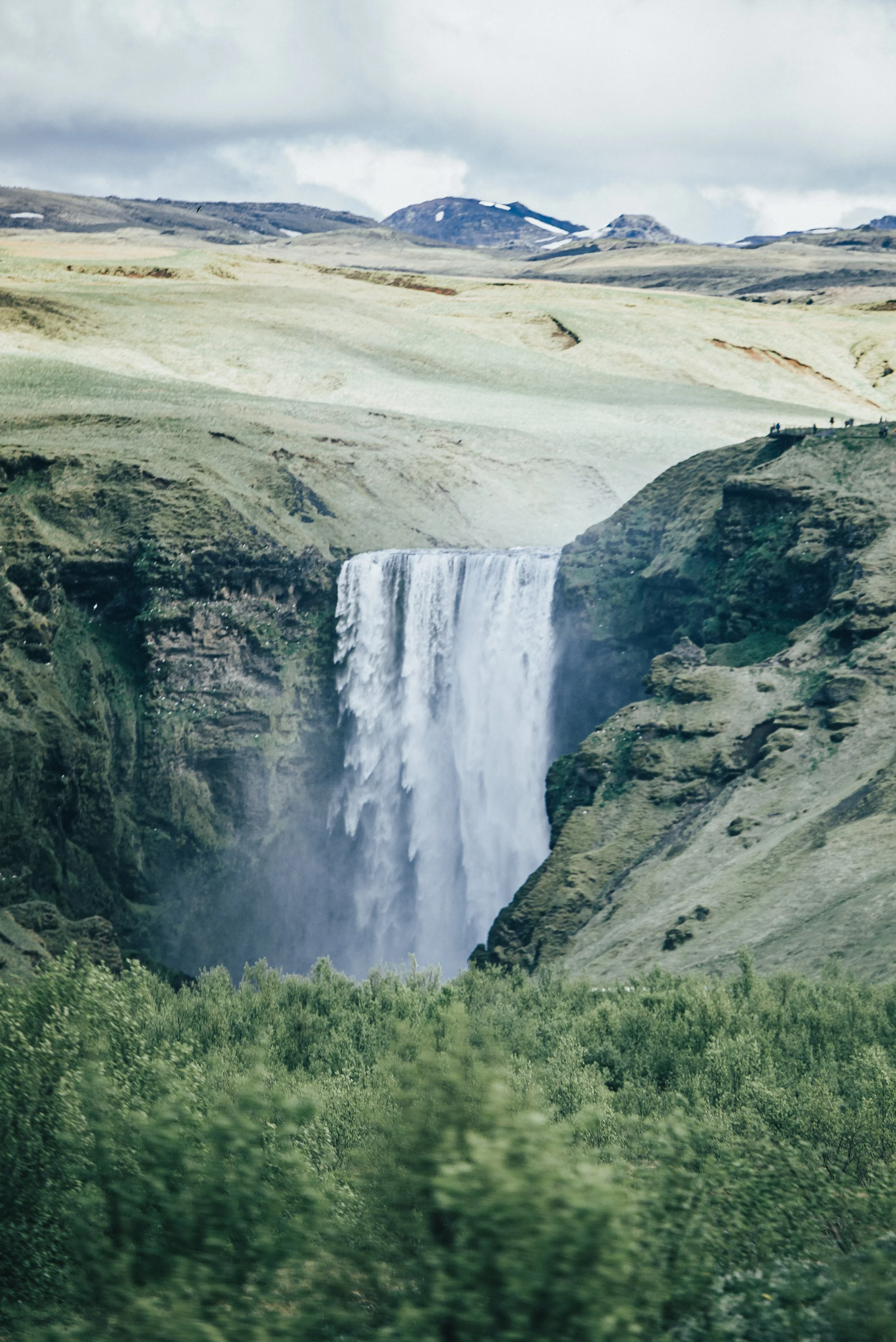
Skógafoss Waterfall
Reynisfjara Beach and Dyrhólaey
Sólheimajökull Glacier
Solheimasandur Plane Wreck
Vik
Eldhraun Lava Field
Fjaðrárgljúfur
When is the best time to visit?
Any time of the year! All seasons are beautifully different.
For new travelers that may not be the most comfortable in the snow, I would recommend staying within late spring to early fall. Ideally, summer would be the best, most amount of sun and the least amount of rainfall.
However, don’t let this deter you from exploring other times of the year. There is just as much magic in the winter, like the chance to see northern lights! No matter which time of year, make sure to keep your itinerary flexible and an eye on the weather report just in case of any sudden weather changes.
How long does it take to drive?
From Reykjavik to Fjaðrárgljúfur, without stopping, is about a 3 ½ hour drive down route 1. Of course, you most likely won’t be doing that drive without going anywhere else but that is a great gauge on how wide the region is. Also, that’s good to know if you made it all the way to the end and then find yourself racing back to catch a flight. I may or may not have had to do this once. The Golden Circle that is within the region and not included in that 3 ½ hour time is a loop off of route 1 and is detailed in the information below.
Now that I’m here, what do I do?
Check out my itineraries!
7 Day Iceland Road Trip - COMING SOON
2 Week Ring Road Itinerary - COMING SOON
Iceland’s Golden Circle
What is the Golden Circle in Iceland?
The Golden Circle is a popular circular route in southern Iceland. It gets its name from Gullfoss, one of the major waterfalls on the route. It is one of the most popular day tours from Reykjavik and can be done as a solo self-drive road trip or with an organized tour. The route stretches for around 186 miles/300 km and starts and ends in Reykjavik. You will find that many travelers flock to the Golden Circle due to its proximity to the capital and because many of Iceland’s top sights and attractions can be found here! Whether you are on a long trip or a quick one like this one, I would recommend the Golden Circle to anyone visiting Iceland.
How long does it take to drive the Golden Circle?
Starting in Reykjavik, the round trip should take around 6-8 hours. This includes around 3.5 hours of driving time + however long you decide to spend at each attraction. Additionally, the Golden Circle does not require a 4x4 vehicle. You are able to reach each location easily with any car.
Map
Locations
Thingvellir National Park
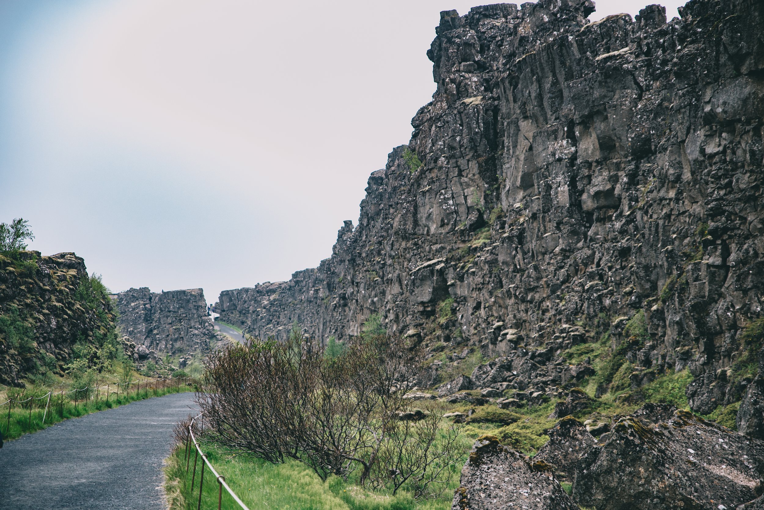
Ready to be in two continents at once? Þingvellir National Park, pronounced Thingvellir in English, is one of Iceland’s UNESCO world heritage sites. The area is an important cultural and geological site to Iceland. A continental divide cuts right through the park. The rift valley is caused by the separation of two tectonic plates, the North American and Eurasian, marking the crest of the Mid-Atlantic Ridge. Here is also where the country’s first parliament was located. For hundreds of years, 930 to 1798, Icelanders would meet here to discuss laws and politics. You can just feel the history here. Now, the parliament is located within Alþingishúsið in Reykjavík.
When you arrive, there is a parking lot that accommodates plenty of cars. Before continuing to the park make sure to stop at one of the pay stations located inside the visitor center. To the right of the building there is a viewpoint that I recommend making a stop at before following the path down between the two continents. The path is very well maintained and easy to walk with plenty of informational reading along the way.
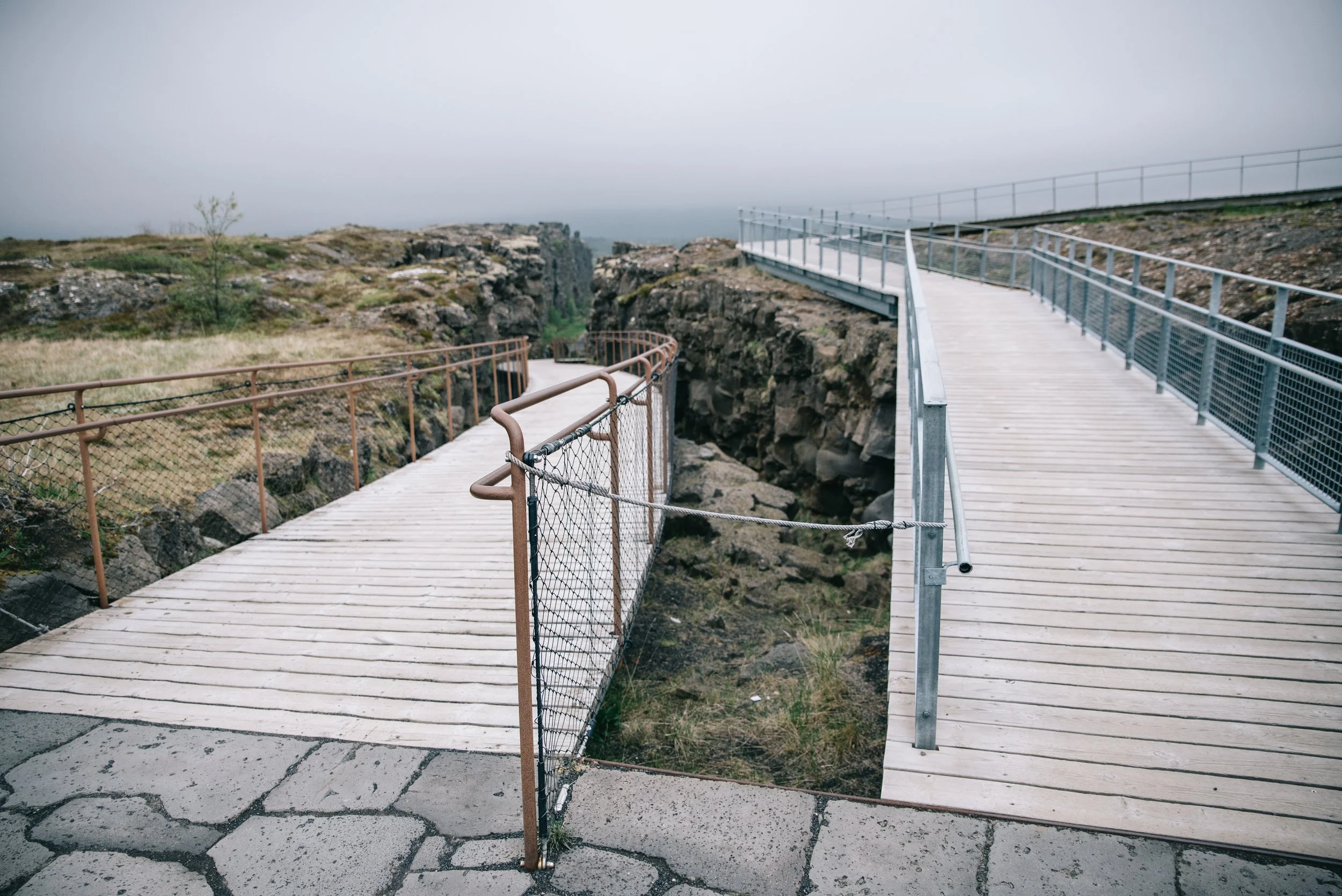
Look for this area, the right leads to the viewing platform and the left leads down between the valley
If you follow the path all the way down you will see your first waterfall of the trip, Öxarárfoss. For anyone who is a Game of Thrones fan, nearby there is a rift through the rock that was used as a filming location. One way, the walk is about 20 minutes, but make sure to add to that time to allow for taking in the sights and reading the informational boards. If that is too time-consuming, I think walking about 10 minutes down and turning back lets you see plenty.
Up for some adventure? An even cooler way to see the rifts is by snorkeling! There are tours that bring you through the Silfra Fissure nearby. Very cold but definitely an adventure worth doing. If you do not have time to do both, I would recommend picking one or the other. The snorkeling would probably take around 3 hours or so.
Geysir Geothermal Area
The Geysir geothermal area is within Haukadalur Valley and in the northern part of the Golden Circle. When you arrive there is easy, free, parking by the visitor center. After parking, cross the street to enter the main geothermal area. As you follow the path you will be surrounded by many bubbling mud pots and steaming earth, but the main attractions are Great Geysir and Strokkur Geysir. Great Geysir is the earliest documented geyser in European literature and has been active for around 10,000 years. Now, it is pretty much inactive. However, before reaching Great Geysir, you will see Strokkur. This geyser erupts every 6-10 minutes, shooting boiling hot water almost 131 feet (40 meters) in the air.
As you walk up to Strokkur you can go right and view it from that side or keep walking and you will reach Great Geysir. You used to be able to walk completely around Strokkur but as of my visit in 2021, it has been closed off, but you can still reach the other side. Go back to the front of it and cross over following the left side of the geyser. That side allows you to get up closer and see the water inside. After watching Strokkur go off a couple more times, turn around and follow the trail up to see several more hot springs, mud pits, and geysers around the area.

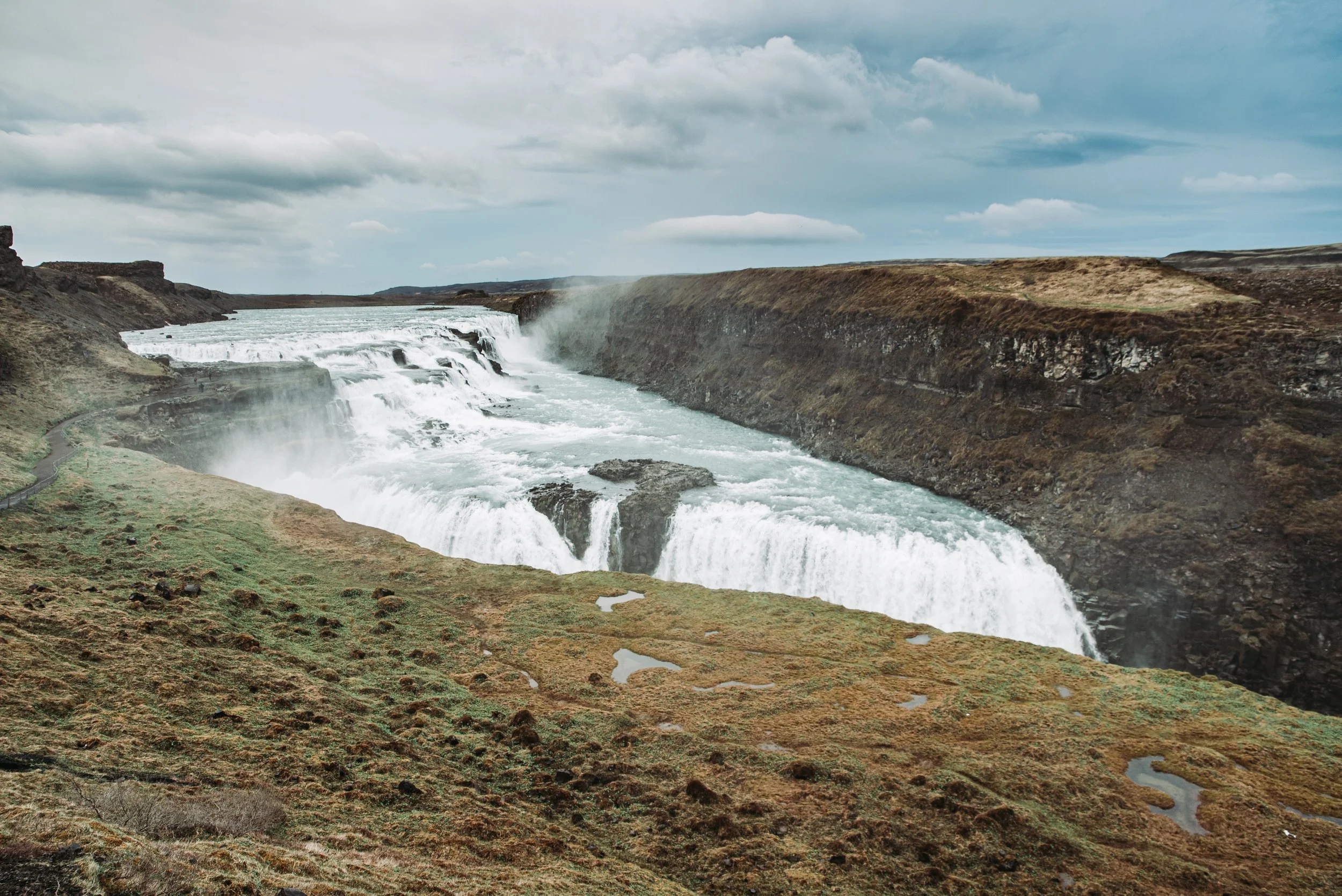
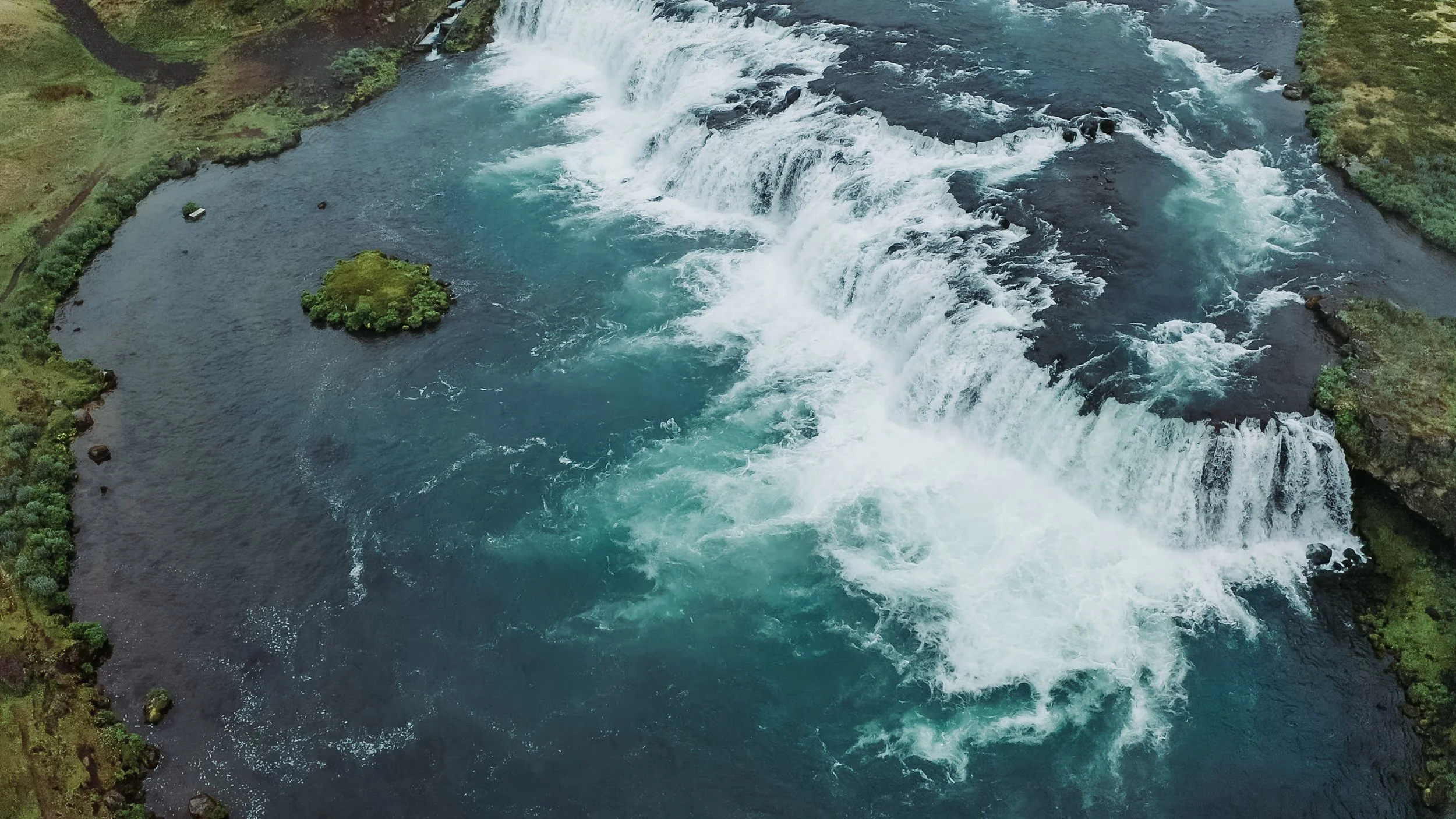
Gullfoss
Next up is Gullfoss, or “Gold Waterfall”. Gullfoss is one of the largest and most powerful waterfalls you will see on your trip, and how the Golden Circle gets its name! This location again includes a good size parking lot and a great visitor center. To reach the waterfall walk to the left of the visitor center and follow the path down where you should quickly start to hear the powerful water cascading down.
There are two ways to see the falls, from above and walking right up to it. As you reach the stairs, turn left to head towards the lookout. After checking that out, walk back to the stairs and walk down to the waterfall. Depending on the time of year, there may be an additional trail that brings you right up to the side of it. If that is closed it is still a breathtaking view from the main area.
Path from the parking lot to the waterfall
Additional Sights Near the Golden Circle
Faxifoss
Many miss Faxifoss when traveling along the Golden Circle. Although it is much less powerful and dramatic than Gullfoss, it is very peaceful and of course, much less crowded. There is a large lot, so no worry about parking. After parking, you can walk to the end of the lot for a great quick view of the waterfall or turn right and follow a short trail to another viewpoint. If you feel like you have some more time, you can follow a path to the left and get a closer look.
Note: If you’re using Google maps, and having trouble finding it, try typing in Faxafoss or just Faxi.
Parking lot and path/viewing platform
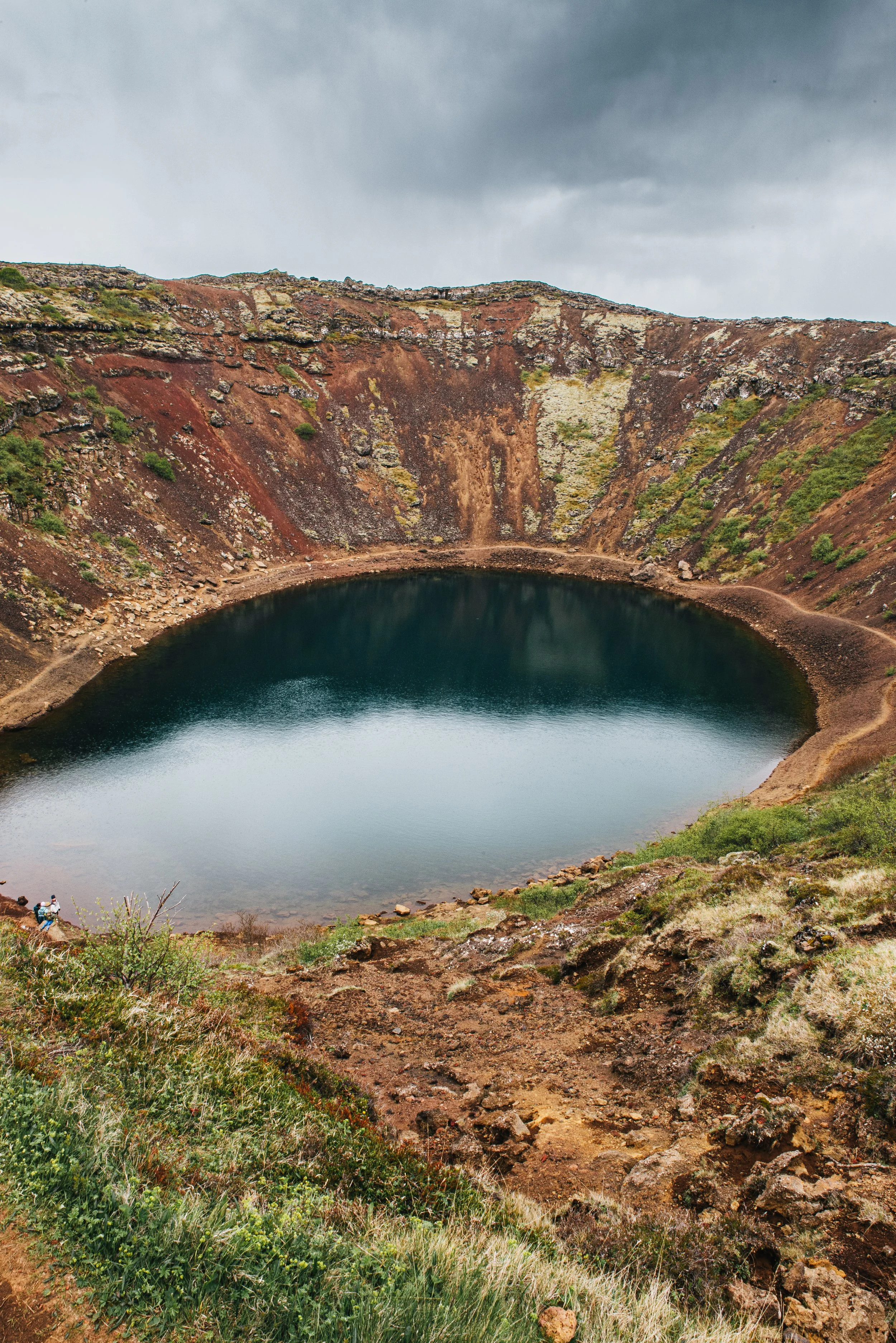
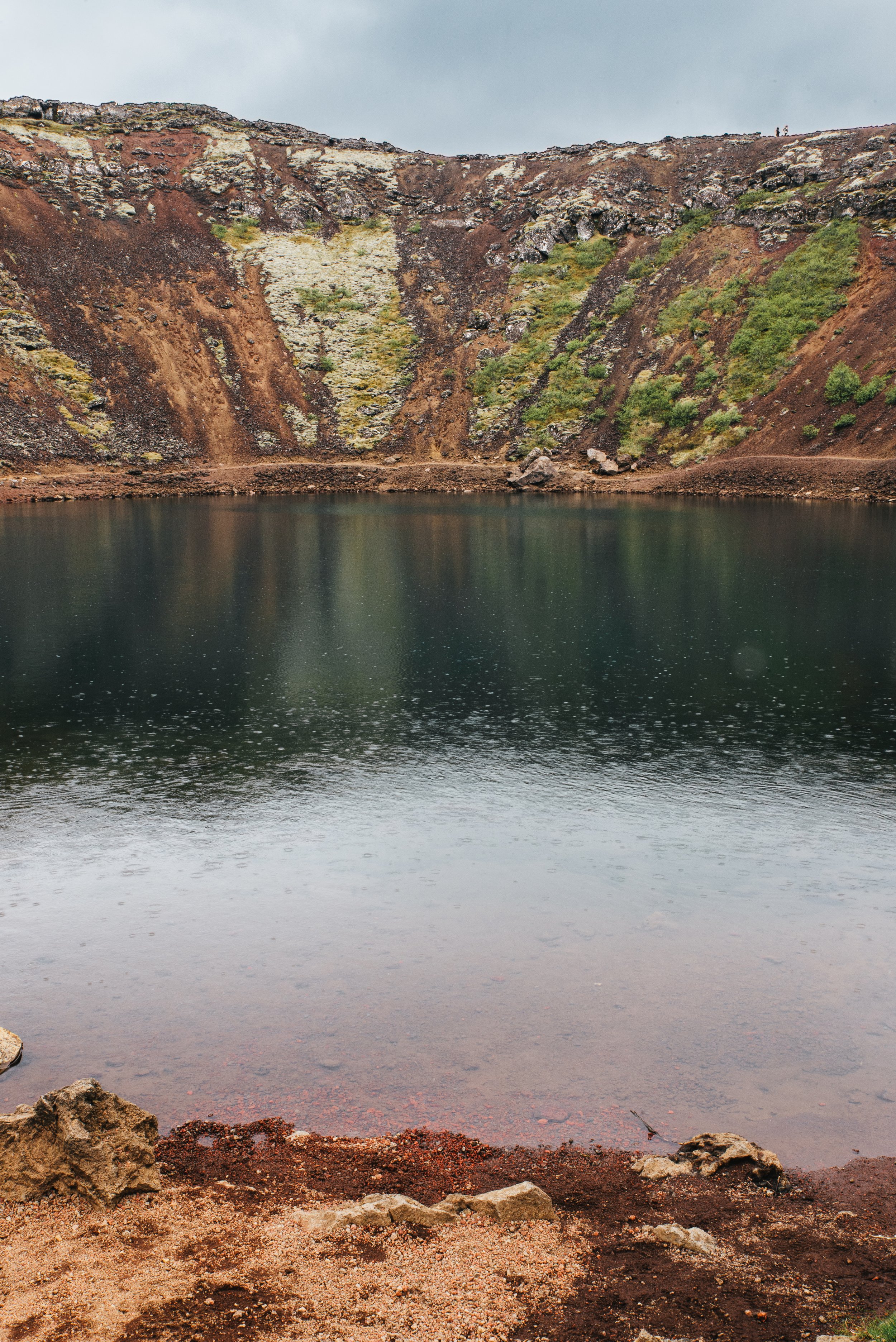
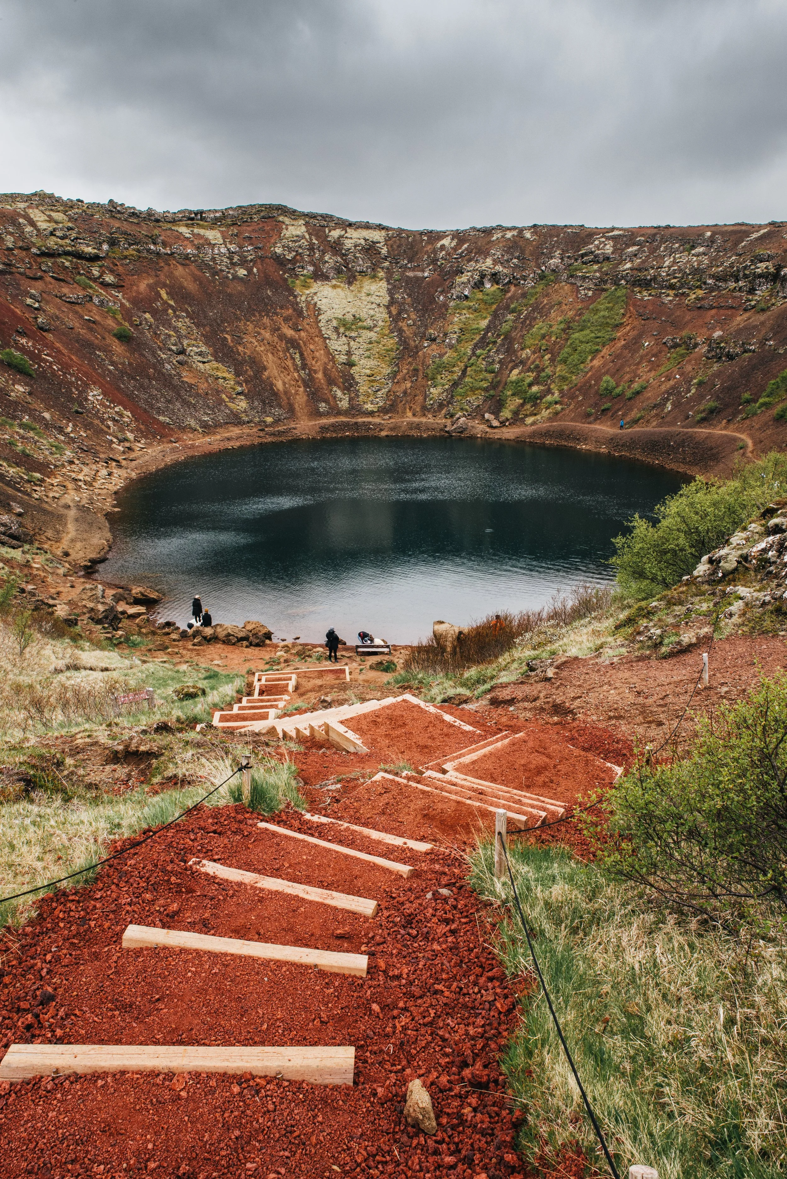
Kerið (Kerid) Crater
Kerid crater is a massive red rock crater with a lake in the middle that was once a typical cone-shaped volcano. The surrounding rocks are fiery red and orange combined with bursts of black and green with a deep blue lake at the bottom. The color of the lake depends on how sunny/cloudy it is when you are there.
When you arrive, there is a small parking lot. Parking is free but there is a small per person entrance fee (about $3 each). After paying, to the left is a short trail leading up to a wonderful viewpoint of the crater. Then, to the left of the lookout, there is a short, 5 minute, trail that leads down to the lake allowing you to walk right up to it.
Iceland’s Southern Coast
LAVA Centre
Iceland’s itineraries are filled with not many indoor activities and I’m sure most of you are here for the nature. However, I highly recommend this museum. LAVA Centre is an interactive and high-tech educational exhibit illustrating the volcanic activity, earthquakes, and the creation of Iceland over millions of years. It helps you have a deeper understanding and appreciation of everything you are visiting and driving past while on your trip. Additionally, there is a digital display right when you walk in showing all of the recent volcanic and earthquake activity in Iceland along with a great shop and restaurant.
Note: There is a ticket for just the museum, just the cinema, or both. If you have the time I recommend both, the movie shown in the cinema is excellent, but if you have to pick one then I would go through the museum.
The LAVA Centre is open every day from 9:00 AM – 4:00 PM
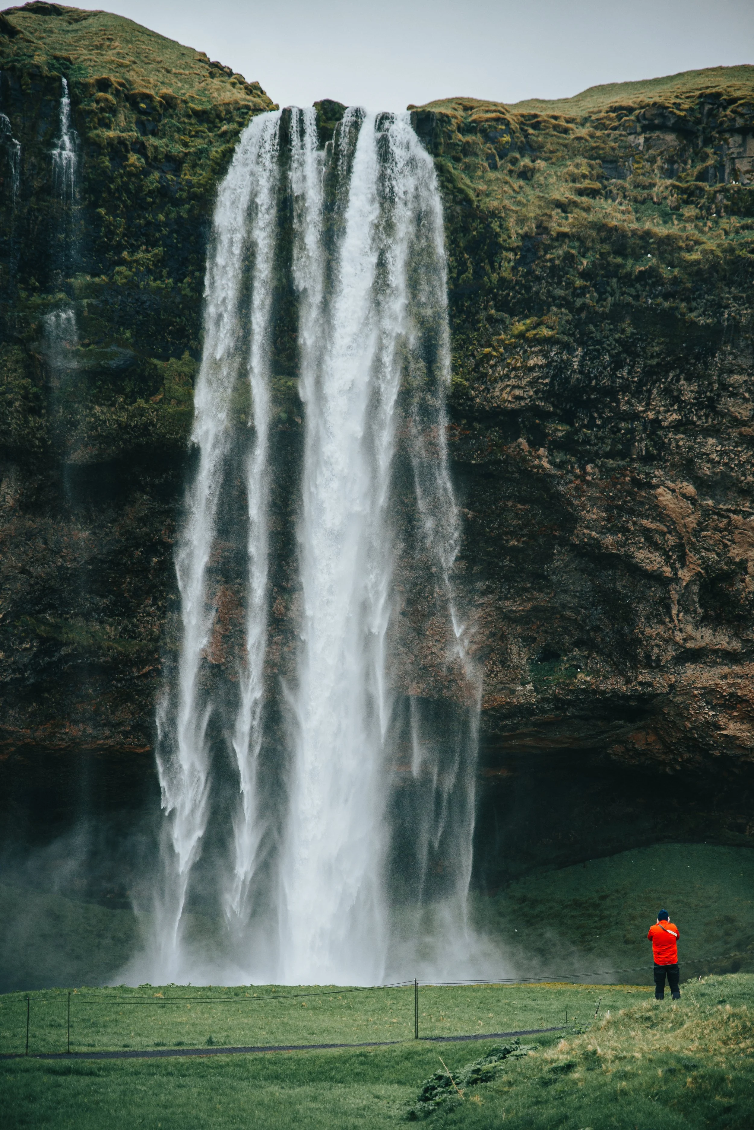
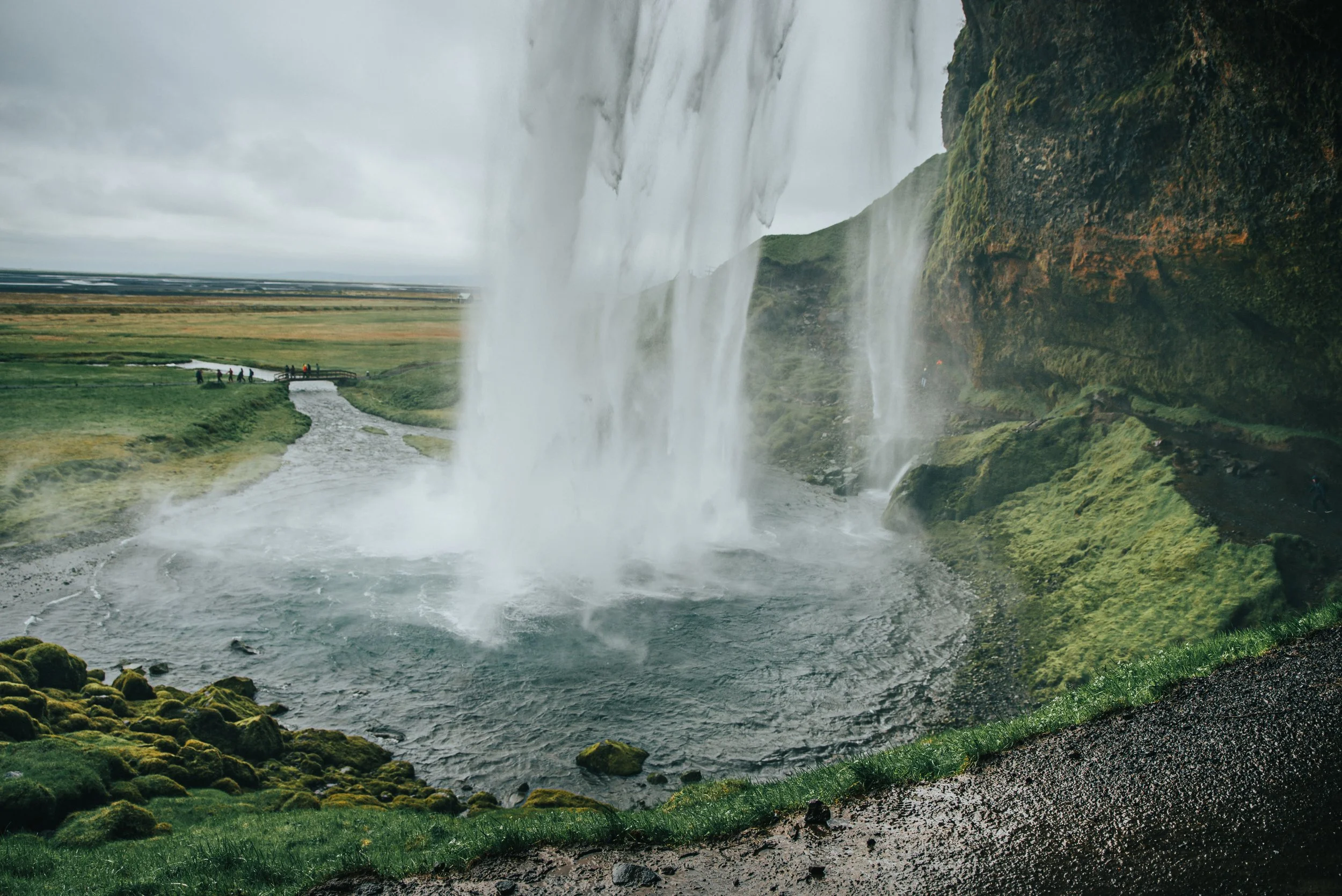
Seljalandsfoss and Gljúfrafoss Waterfalls
Seljalandsfoss and Gljúfrafoss are two of my favorite waterfalls in Iceland. Seljalandsfoss’s water cascades 200 feet, 60 meters, over steep cliffs and is part of the Seljalands River which originated from the glacier Eyjafjallajökull. I’m sure you have seen photos of Seljalandsfoss from behind since it has its popular path allowing you to see the waterfall from a different perspective. The path is only open during the warmer months since the water splashing down from the waterfall covers the entrances, making it too dangerous to go on. If you are visiting in the winter I would not skip this stop, you can still get very close and get a great view from the front. The ice is also very cool to see since the falling water freezes around the grass.
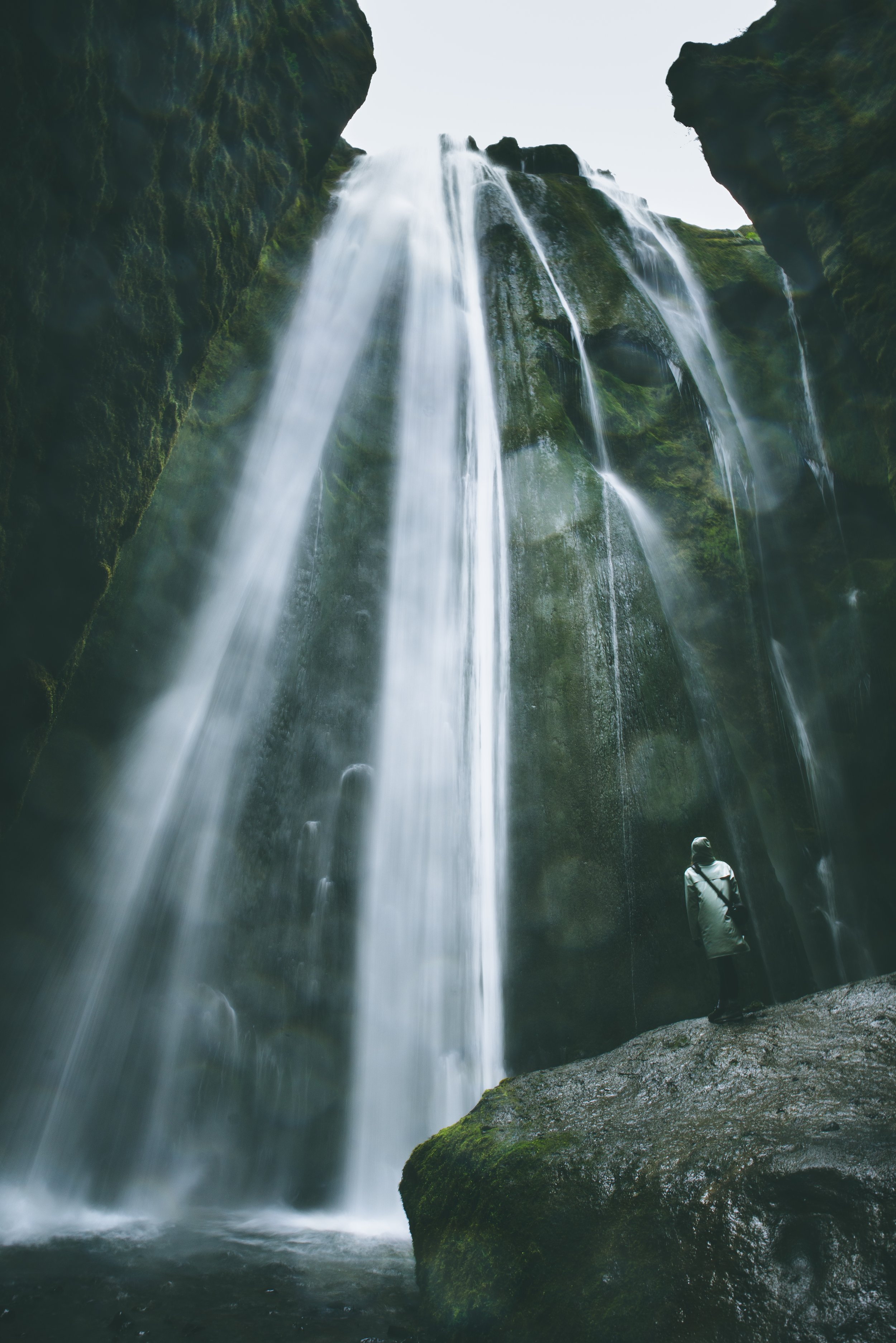
Gljúfrafoss is a little bit of a hidden treasure. You most likely wouldn’t know it was there by just visiting Seljalandsfoss. If I had to quickly say what my #1 waterfall was in Iceland I think I would say this one without hesitation. Partially hidden behind the cliff rock, there is a narrow canyon that opens up to a small area where Gljúfrafoss is flowing down. It’s such a cool experience to walk through, balancing on rocks sticking up from the river, and then looking up to see the water coming down. Once inside the canyon there is a place to walk around, you aren’t forever balancing on those little rocks, and a large rock in the center you can climb up on and get a great picture. To get to Gljúfrafoss, follow the path left of Seljalandsfoss towards the campground until you reach the river, then you will see the canyon immediately to your right.
Note: Gljúfrafoss is labeled Gljufrabui on Google maps.
Parking is easy with a big lot close to the waterfall. Make sure to pay at the station before leaving the lot. There are also three stands that house a small store, a food stall with great hot drinks and food, and bathrooms.
Note: If going behind Seljalandsfoss or into the canyon for Gljúfrafoss, make sure to wear waterproof clothing. You will get wet!
Skógafoss Waterfall
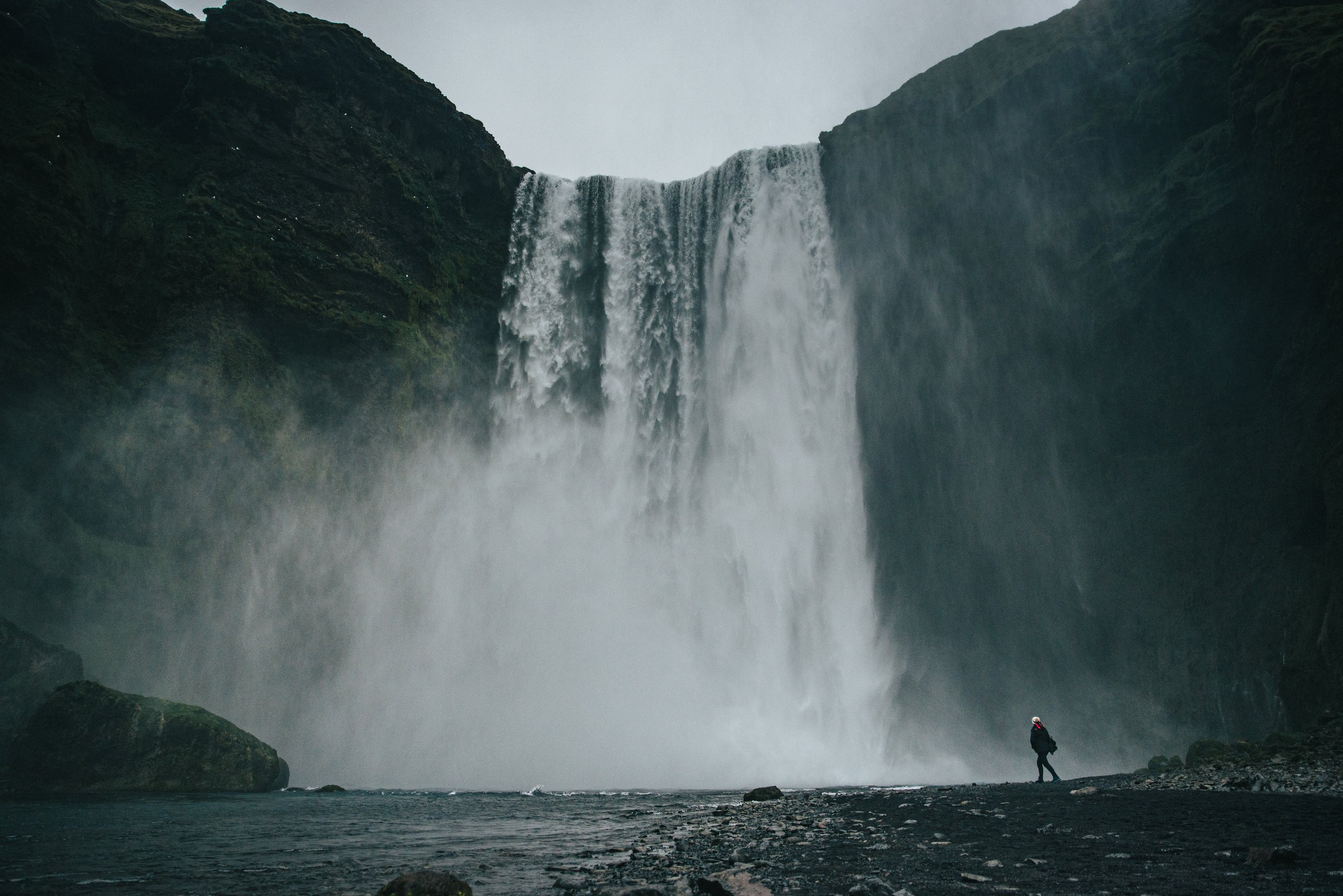
Skógafoss is a beauty and one of Iceland’s biggest and most famous waterfalls. Feel like you’ve maybe seen it before? Well, you’re right, it was used on the show Game of Thrones! It’s water, which comes from the Skógá River, has a drop of around 200 feet, 60 meters, and is 82 feet, 25 meters, wide. This cliff marks the former coastline before later receding, it is now about 3 miles from the cliffs. The best way to see it is to walk right up to it and feel the power of the water crashing down.
To the right, there is a staircase built into the mountain side leading up to the top to a small viewing platform. You can get a bird’s eye view of the waterfall and the surrounding area and see where the waterfall is flowing from.
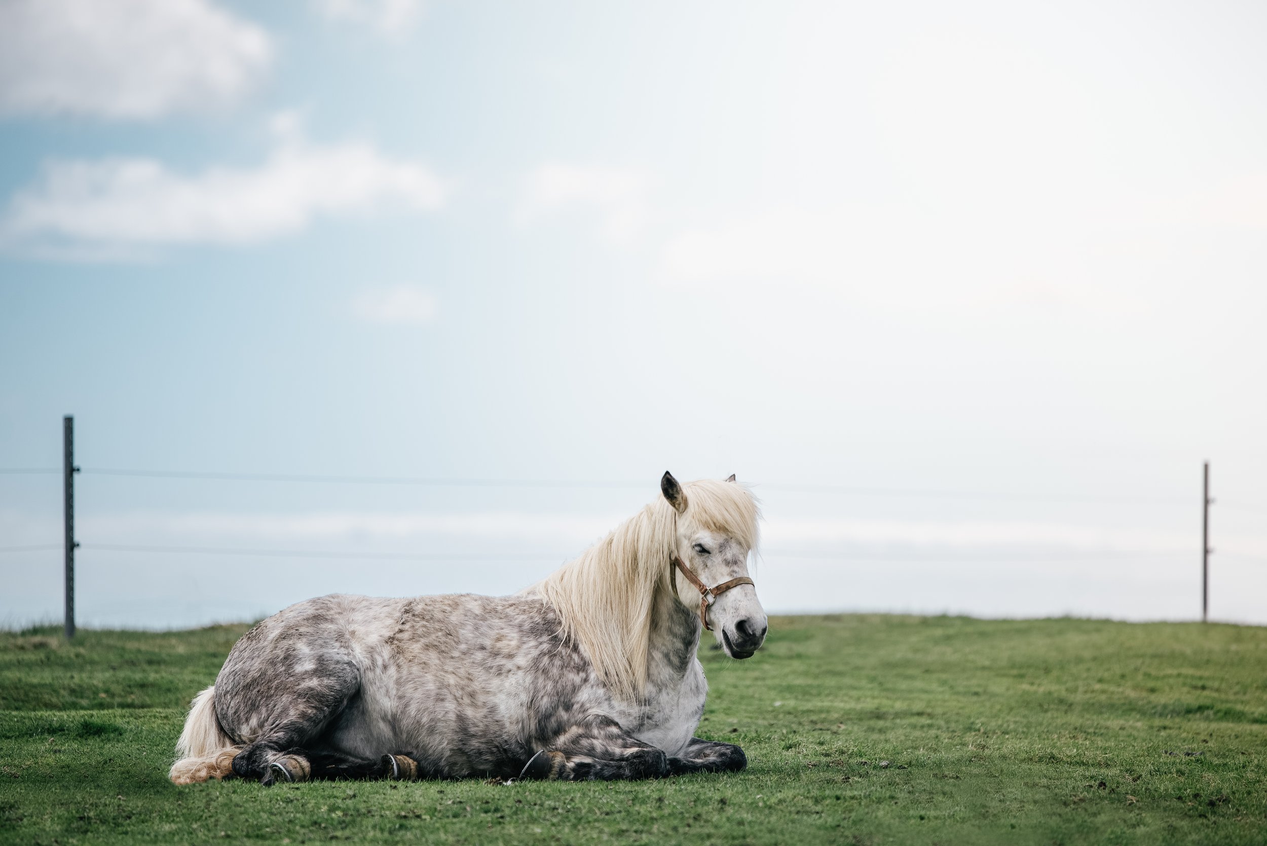
Parking is also very easy here with a large parking lot and minimal walking to get to the waterfall. There is also a bathroom here with a small fee, make sure to have cash. I have also seen sheep just about every time I have been here so if you were looking for a way to see then while out of the car, here is the place!
Solheimasandur Plane Wreck
On one of Iceland’s remote black sand beaches along its southern coast lies the remains of an abandoned US Navy DC plane. In 1973 the plane was flying from Hofn Hornafjördur Airport to Naval Air Station Keflavik but halfway through the flight the plane ran out of fuel and crashed on the black sand beach at Sólheimasandur. It was later found out that the pilot switched to the wrong fuel tank causing the plane to not have sufficient fuel. Luckily, everyone on the plane survived.
Now the plane is there for everyone to visit and is definitely worth the hike. Along route 1 there is a small parking lot at the top of the trail. The hike to the plane is about 2 ½ miles, 4 kilometers, and a 1-hour walk, one way, along the black sand beach. Make sure to bring good walking shoes for the trek. Additionally, there is a shuttle that runs every day from 10:00 am to about 5:00 pm that you can take for a fee. Click here for tickets and schedules. If both of those options are a little slow-paced for you, there are also quad tours that allow you to drive right up to the plane!
The plane is on private land so please be respectful so everyone in the future can continue to see this cool sight!
Sólheimajökull Glacier
Sólheimajökull Glacier is an outlet from the massive Mýrdalsjökull icecap and is surrounded by some of Iceland's most grand volcanoes. It is also one of the most visited glaciers in the southern region. There is an easy, decent size parking lot here that leads to the trail. When visiting on your own it is important to only approach it but not climb on it unless you are on a guided tour. Sólheimajökull currently measures about five miles long, eight kilometers, and just over a mile wide, 2 kilometers. However, it appears much large due to how it originates from Mýrdalsjökull. Sadly, due to climate change this glacier is melting, along with all the others in Iceland, and may be gone within decades.
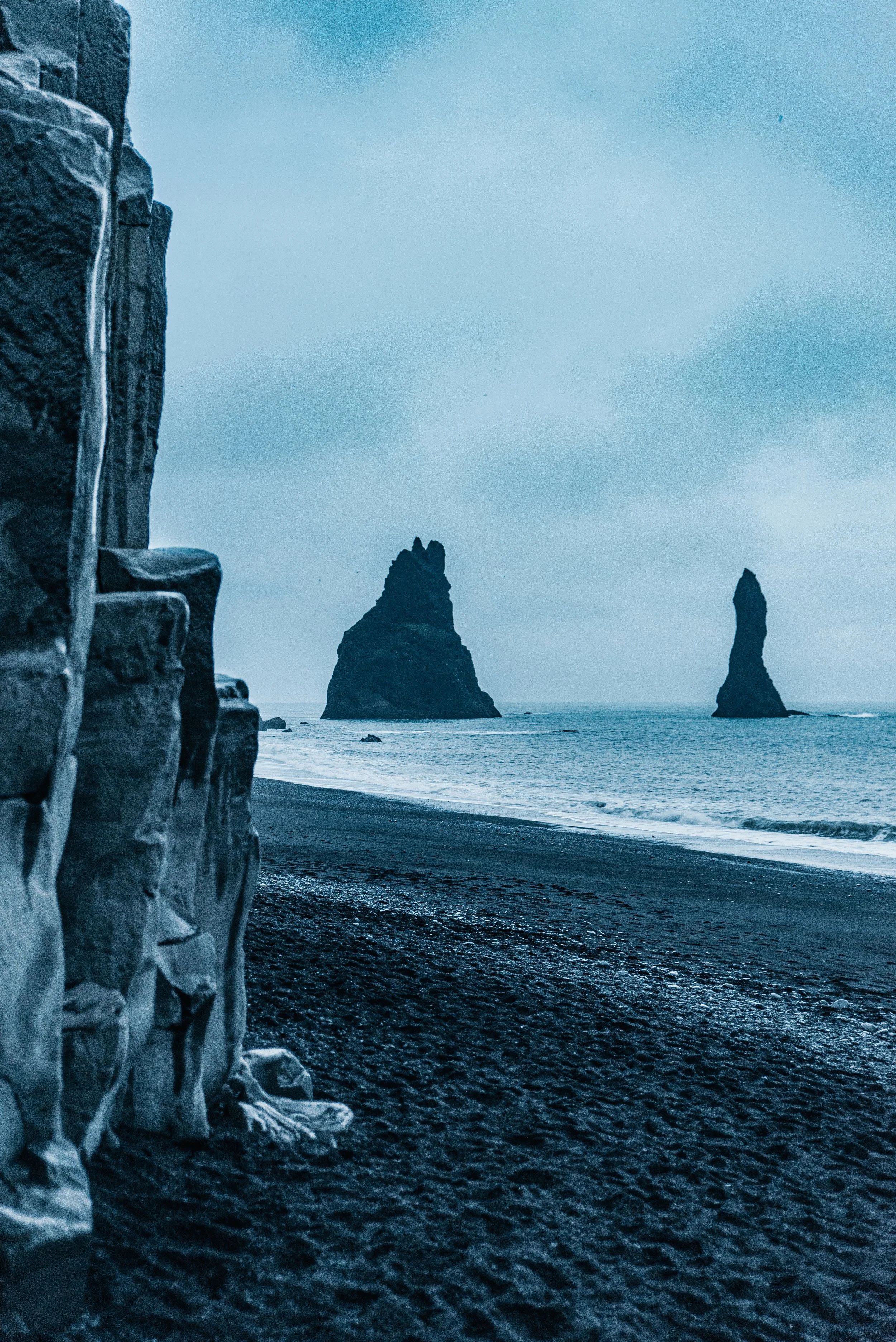
Reynisfjara Beach and Dyrhólaey
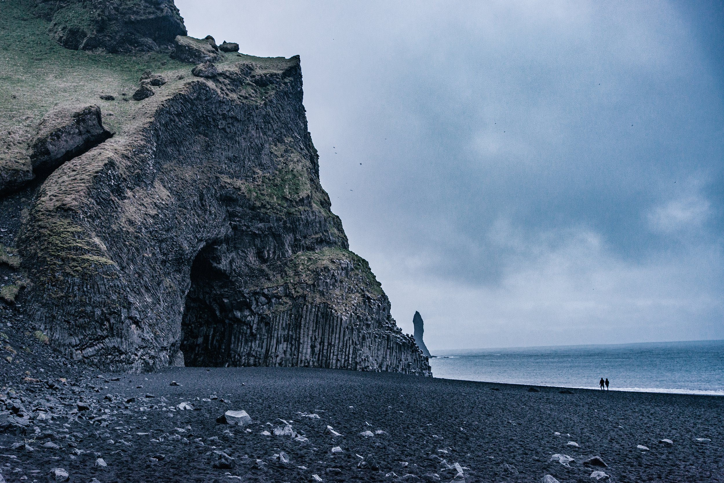
Last stop for today, Dyrhólaey and Reynisfjara Black Sand Beach! If you are running late in your day but have time for one more stop, I would go to Reynisfjara and save Dyrhólaey for the next day. The way to Reynisfjara is an easy paved road with a parking lot and a restaurant right at the beach. After parking it is a short walk to the black sand beach, with very important warning signs that you must adhere to. I have photographed them and inserted them below. Many tourists die every year due to the dangerous sneaker waves at this coastline. Never get too close to the water, or in it, and never turn your back to it.


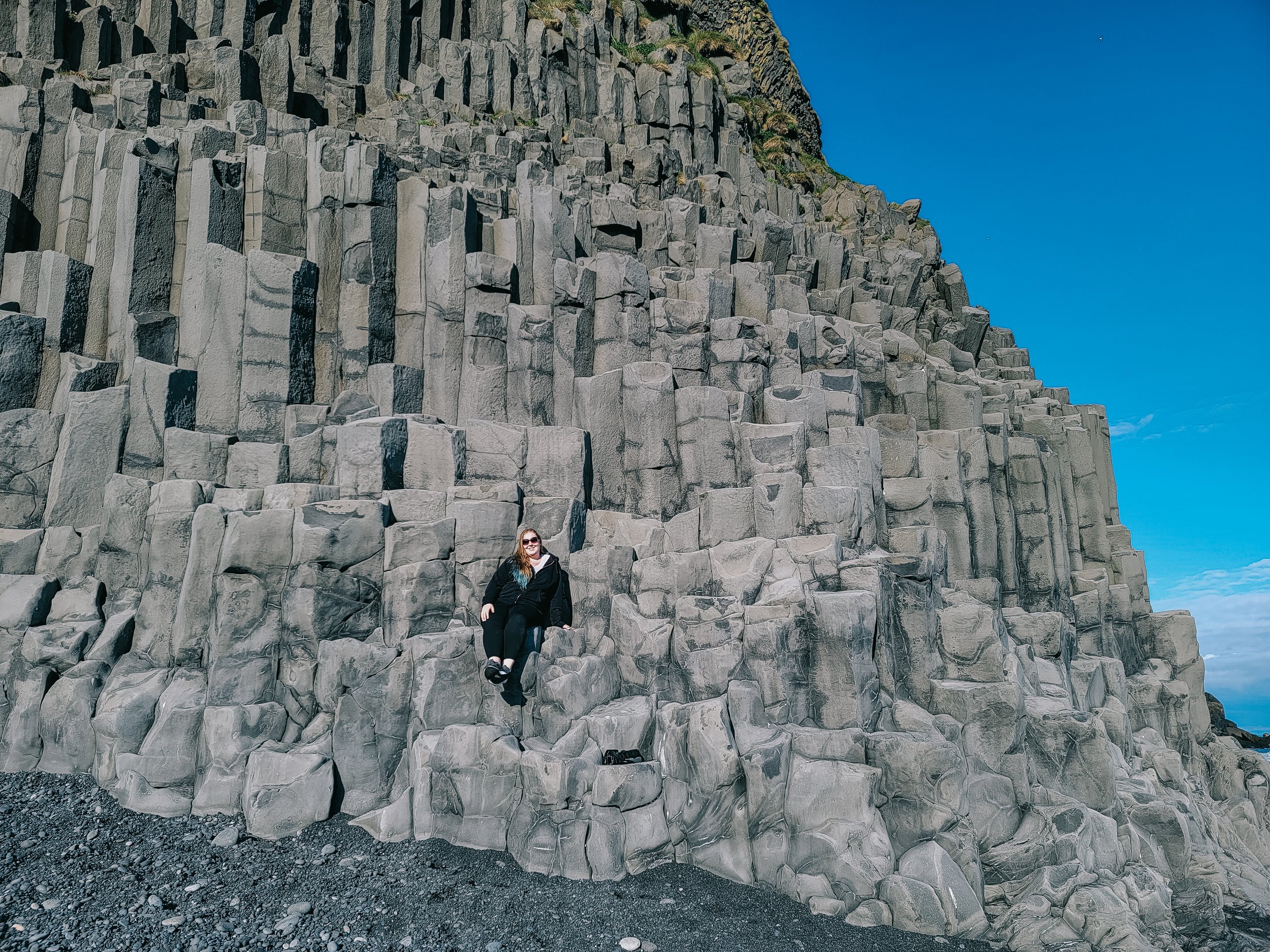
Once on the beach there are beautiful views of the coastline that seems to stretch on forever and insanely high basalt columns that are so cool to see. In photos they don’t seem as tall as in person. In the image below I must have been almost 20 feet off the ground! Looking around the corner you can see Reynisdrangar, large basalt sea stacks jutting out from the water. The legend behind the stacks is that once two trolls dragged a three-masted ship to land unsuccessfully and when daylight broke they became needles of rock.
The road to Dyrhólaey is before the mountain pass while the road to Reynisfjara is at about the middle on the way to Vik. Dyrhólaey offers stunning views of Reynisfjara Beach from above, a lighthouse, and the chance to see puffins if you are there at the right time of year! The area got its name from an almost 400 foot, 120 meter, high arch that protrudes from the cliffs and was worn away from the ocean. Dyrhólaey means “door hill island” and described the cliff perfectly. The Dyrhólaey lighthouse is one of the highlights of the area and had been sitting on top of the cliffs since 1927.
Note: If you are visiting during May/June, Dyrhólaey may be closed overnight due to the area being a major Puffin nesting location. Dyrhólaey is a nature preserve that protects the unique birdlife. Puffins tend to go out to sea and fish during the day but there is still a big chance that you will see them here during this time of year.
Also, there is a split in the road about midway. If you go straight, the more paved option, this leads to the main parking lot, a bathroom, and viewpoints of the arch and surrounding coastline. If you take the road to the right, this is the one that leads to a smaller parking lot, the lighthouse, arch, and the famous view you might have seen on Instagram.
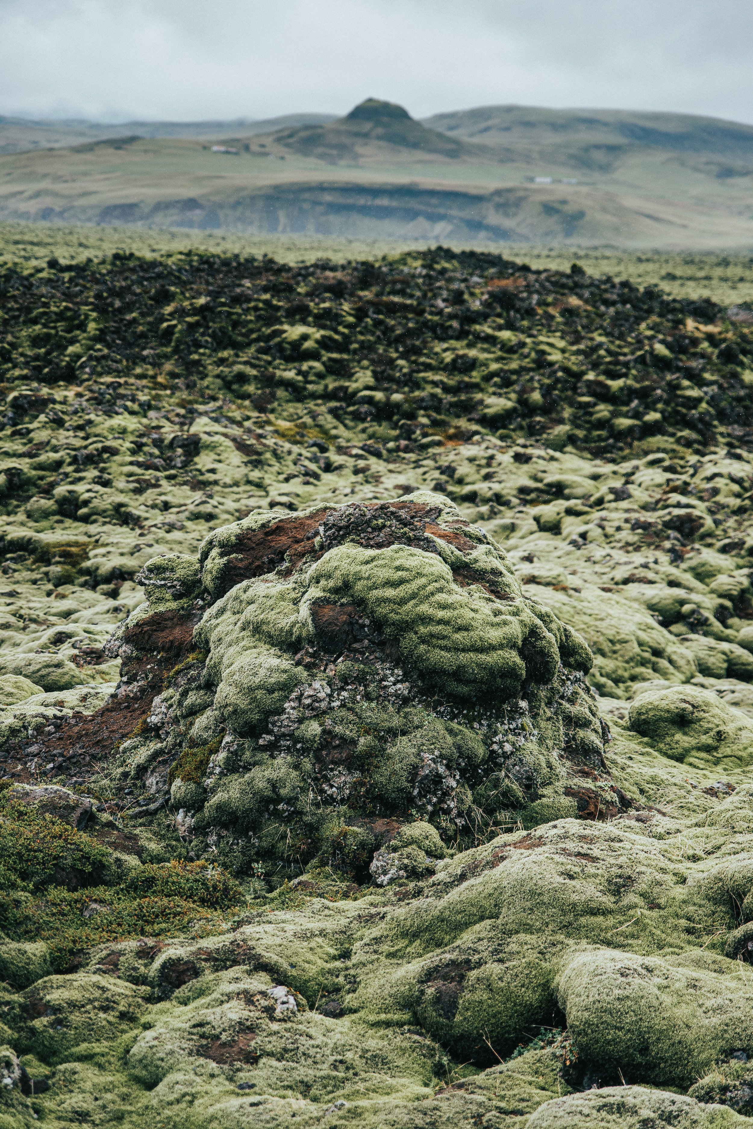
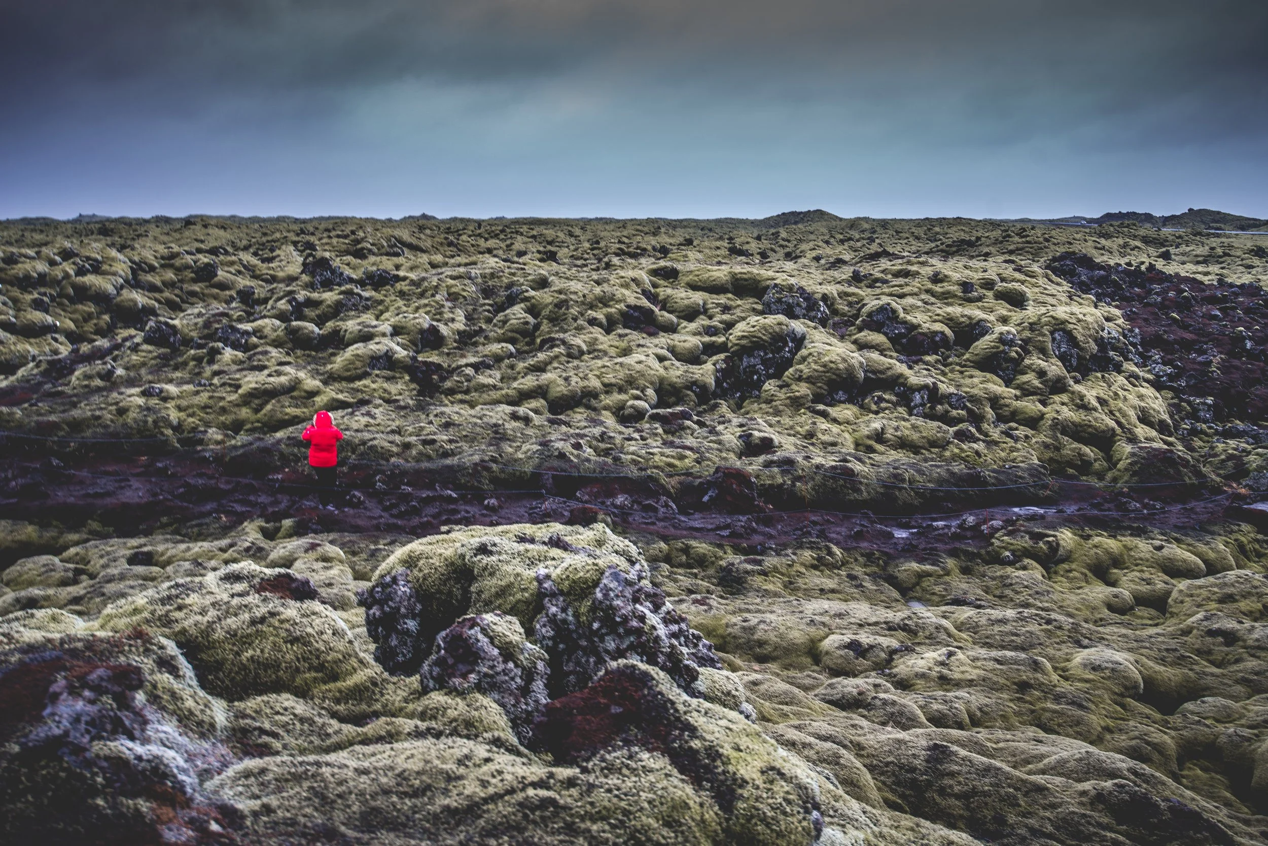
Eldhraun Lava field
Eldhraun lava field was created during the Laki eruption from 1783-1784 and is one of the largest of its kind, covering about 218 square miles (565 square kilometers). The eruption affected Iceland and Europe as well and is believed that it contributed to the French Revolution because of the haze it created blocking sunlight. In Iceland, the aftermath lead to disease, crop failure, and between 53-82% of domestic animals and 20% of humans perished.
Despite the sad history, it is now a stunning mossy wonderland and an easy stop off of route 1. When you arrive there is a spacious parking lot, making parking easy, and a path that leads to a viewing platform. There is also a small narrow path next to the platform that allows you to walk through the field.
Note: The moss growing on the hardened lava is a huge part of what makes this place so beautiful and it took an enormous amount of time to grow. Please be respectful of nature and do not walk on the moss. It is also not advised to walk on the lava rocks because the rocks underneath may be unstable.
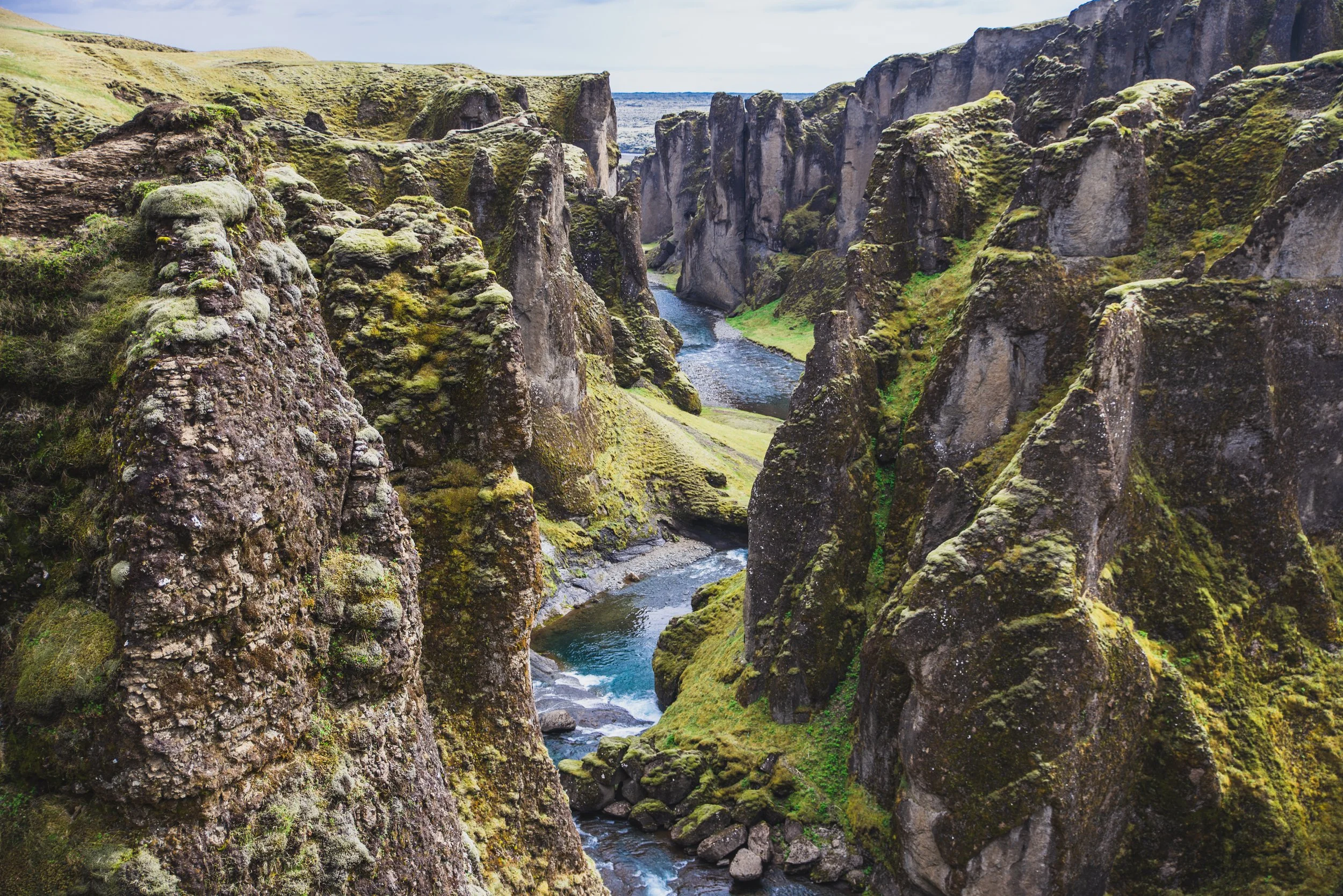
Fjaðrárgljúfur
Fjaðrárgljúfur is a dramatic canyon in Southwest Iceland with the Fjaðrá river flowing through it. It was created from years of erosion caused by the flowing water from nearby glaciers. The canyon walls are up to over 300 feet deep, 100 meters, and over 1 mile wide, 2 kilometers.
Fjaðrárgljúfur is another spot you may recognize from the media and/or news. Justin Bieber featured this location in his 2015 music video, “I’ll Show You”, (along with being used as a backdrop in Game of Thrones). Previously, Fjaðrárgljúfur was largely overlooked before the music video brought attention to the canyon. The trails couldn’t handle the influx of tourists and had to be closed for a couple of years to allow nature to grow back. Now the area is back open and better prepared to be seen again.
To reach Fjaðrárgljúfur from route 1 turn onto 206 Holtsvegur and follow the road about two miles. At the first fork in the road make sure you stay left and keep following the road straight to the parking lot. The road to Fjaðrárgljúfur can become a bit rough and windy towards the end but your car should be able to handle it. Of course, use your best judgment if the road is snowy and icy.
Note: There is an F road connected to this road about 2/3 of the way up, do not turn down this road. Especially if you do not have the appropriate car for such a road. F-Roads (fjall which means mountain in Icelandic) are unpaved gravel roads that are not regularly maintained. Regular cars are not allowed on these roads, and they are closed during the winter months.
When you reach the end of the road there is a small parking lot with enough room for just a row of cars. There is also a small building if you can even call it that, with two bathrooms. The canyon is beautiful from the moment you park. At the beginning, there is a bridge that you can walk on to see the canyon and river from the front. To walk up to the viewing platform, the entrance to the trail is next to the bathrooms and is easy to see. It is a very easy trail with only a moderate incline. The walk to the platform is about a mile, but you will want to stop many times to take in all the scenery. The whole experience is well worth it.
Please stay on marked paths and the new viewing platform. We want the canyon to be here for a long time for everyone to enjoy!

Fagradalsfjall Volcano Hike
Ready to hike an active volcano? In March 2021, Fagradalsfjall started erupting on the Reykjanes Peninsula just 40 kilometers, about 25 miles, from Reykjavik! Don’t worry, it is considered an effusive eruption, so the lava steadily flows out of the volcano rather than shooting into the atmosphere. This allows for safe hiking around the area and no danger to the residents in Reykjavik. Don’t let your guard down too much though when on your hike. Stick to marked paths, listen to officials in the area, and check reports before heading to the location.
Also, do not stand on the “hardened” lava! I saw too many people doing this. You never know how soft it may be underneath and you do not want to fall through.
Now go enjoy your trip!

Hi, I’m Karen!Travel Blogger & Photographer + Founder of The Everyday Adventure
Here I share travel tips, packing guides, planning help, and photography from many different parts of the world. I help other working 9-5 adventurers get out into the world and see as much as they can with the little time they have available.
Related Posts


Looking for Something? Connect With Me